Funded in part by
NSF grant 0538333

Tectonics Observatory logo

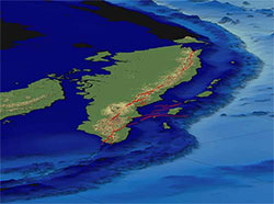
Bathymetry and topography of the Sumatran plate boundary shows the arcuate subduction zone cropping out on the seafloor at about 5 km depth (pale against dark blue) and the Great Sumatran fault coursing through the mountainous, volcanic backbone of the island.  Topographic data is from NASA’s SRTM. View is toward the southeast.

The Sumatran Plate Boundary Project
is a multi disciplinary effort to understand tectonic processes at a plate boundary dominated by the oblique convergence of oceanic and continental plates.  Thus far, we have been mapping the principal active structures, conducting paleoseismologic and paleogeodetic research, monitoring strains with a continuous GPS network, and modeling these data.The Sumatran Plate Boundary is a clear example of a slip-partitioned system: The vertical component of convergence is accommodated principally across the Sumatran subduction zone and most of the horizontal component of convergence is taken up across the Great Sumatran fault.Rupture of the subduction zone has produced earthquakes as large magnitude 9.  Earthquakes with magnitudes up to about 7.5 are common along the Great Sumatran Fault.


For General Audiences
- Earthquakes and tsunamis in Sumatra: What we have recently learned
- More stories, movies, and podcasts on TO research


eXTReMe Tracker
© 2004 Tectonics Observatory and the California Institute of Technology