Western United States Upper-mantle Anomalies - Dynamic Modeling Project
WestUS Home | People | Dangling Slab | Lithospheric Drip | Publications
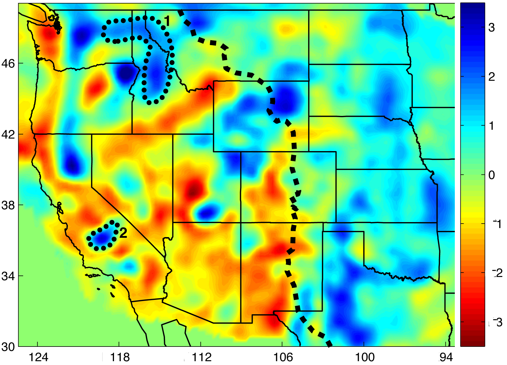
Bird's eye view of upper-mantle structures lying beneath the Western U.S. - This horizontal tomographic section shows the structure of the upper mantle at 195 km depth. The color indicates the relative speed (vp) of the seismic waves when passing through a region. Red means the waves slow down, indicating low-density material. Blue means the waves speed up, indicating high-density material. The linear, high-density (blue) feature extending north from northern California through Oregon and Washington is the "Gorda-Juan de Fuca" slab of the active Cascades subduction zone. The two labeled areas are structures of unknown origin, and thus areas of current research. Credit: Schmandt and Humphreys, 2010a
|
Signals detected by seismometers tell us not only about the location and size of earthquakes, but also illuminate the structure of the earth's interior through which the seismic waves travel, (much like x-rays reveal bones in the body (See Animation).
Recent seismic imaging by the "USArray" (a network of seismometers deployed across the U.S. to record earthquakes and provide high-resolution images of the Earth's interior) has revealed profound structural complexity in the Earth’s upper mantle beneath the western United States.
The figure shows a tomographic section of the western US at a depth of 195 km. The colors indicate the relative speed of seismic waves, and hence the density, of different regions of the mantle. Blue indicates faster waves (hence more dense material) and red indicates slower.
To the right of the dashed line lies the thick, stiff center of the North American continent. It is very dense and hence the region is blue.
To the left of the dashed line lies what is called the American Cordillera, the extensive chain of mountain ranges, basins, and plateaus that runs along the western side of North America. This region was formed by accretion of terrains scraped off oceanic plates during subduction under the North American continent (see Convergent Boundary Animation), as well as subduction-related volcanoes. When subduction shut off, this area then underwent "extension," where the Pacific Plate, travelling north-west, pulled the western edge of the North American plate along with it, causing this area of the continent to stretch and extend (See Animation 1 | Animation 2). Hence this area is thinner and less dense than the rest of the continent.
However, interspersed within this low-density region are high-density (dark blue) structures.
Most notable are a group of high-density structures, about 100 to 1000 km in size, that are suspended from standard lithosphere depths (about 90 km) down to depth of hundreds of kilometers in the underlying mantle, and whose origin is unknown. Our research focuses on two of these structures, labeled #1 and #2 in Fig. 1.
- Our group seeks to understand the formation and underlying dynamics of these anomalous structures.
- Do they come from portions of the overlying continental plate "dripping" off?
- Or are they dangling remnants of old, subducted, oceanic plates, and if so, why didn't they detach and descend deeper into the mantle?
- Or are they some combination of the two, drips and dangling slabs?
Seismic images give us a snapshot at only one time. To go back in time and see the whole story of the formation of these structure, we are currently developing numerical models. We are focusing on two areas, the large "dangling" slab-like body beneath the Pacific Northwest (#1 in figure) and a large mantle lithospheric "drip" beneath the southern Sierra Nevada and Great Valley region of central California (#2).
To help constrain the models, we can deduce snapshots at times other than the present by using geologic observations. These observations provide clues as to the conditions rocks in these areas were under in the past, as well as when volcanoes erupted.
The study of slab remnants beneath the western U.S. is crucial for constraining the history of subduction beneath this unique segment of the North American Cordillera. During the course of oceanic plate subduction, this region may have experienced the opening of multiple slab windows, as well as plume-related migration of volcanoes (e.g., Yellowstone's volcano; See Animation).
The study of lithospheric drips and slab-like structures that are not directly linked to ongoing subduction is likewise crucial for understanding the dynamics and rheologic patterns beneath the western U.S., as well as problems of focused tectonic subsidence and rock uplift, volcanism and heat flow, and global-scale questions of the long-term chemical differentiation of the outer Earth:
Contacts: Jason Saleeby and Mike Gurnis |