Tian Shan Physiography
(Click on Thumbnails for high resolution Images. NOTE: Some high res. images may be several MB!)
Photo Courtesy: Pamir Expeditions

Photo Courtesy: K2 Adventures

Photo Courtesy: Xiang Cao

Photo Courtesy: CNADVENTURE.COM
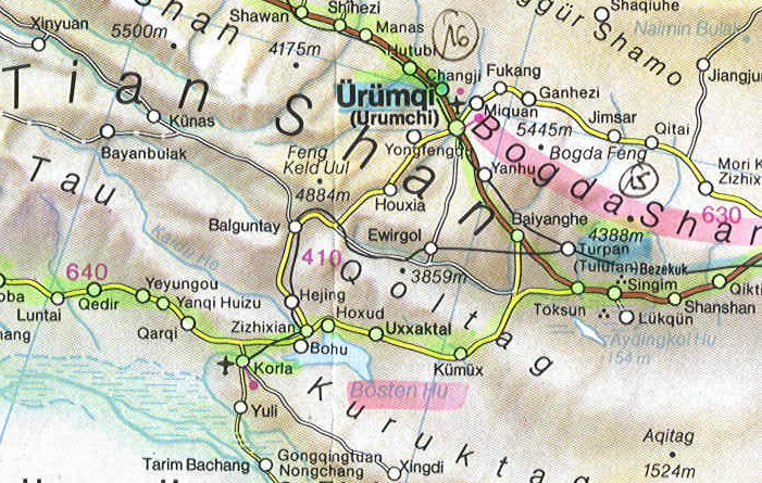
Tian Shan relief is characterized by a combination of mountain ranges and intervening valleys and basins trending generally from east to west. The deepest depression in the eastern Tien Shan is the Turpan (T'u-lu-p'an) Depression, within which is the lowest point in Central Asia (—505 feet or 154 metres below sea level). Thus, the differences in elevation in the Tien Shan are extreme, exceeding four and a half miles. The eastern extension of the Turfan Depression is the Ha-mi (Kumal) Basin. Both basins are bounded on the north by the Po-ko-ta Mountains, with elevations of up to 17,864 feet, and by the eastern extremity of the Tien Shan, the Ha-erh-li-k'o Mountains, which reach a maximum elevation of 16,158 feet. These ranges have steep slopes, with glaciers occuring along their crests. The basins are bounded on the south by the low-rising Chüeh-lo-t'a-ko Mountains. West of the Turpan Depression is one of the greatest mountain knots of the eastern Tien Shan: the O-ha-pu-t'e (Erenhaberga) Mountains, which reach elevations of 18,200 feet. The ridge has considerable glacial development, as well as geomorphological indications that the area was the site of ancient glaciation.
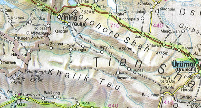
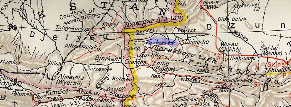
West of 84° E longitude the eastern Tien Shan ridges fork, trending to the southwest and northwest, and enclose the vast Ili Depression, which gradually widens and loses height as it proceeds westward. It is bounded on the north by the Po-lo-k'o-nu Mountains, which have glaciers in the eastern part and are characterized by steeply sloping ridges. This range also gradually descends westward, where, at a height of 6,801 feet, lies the great undrained Lake Sai-li-mu (Sayram), near the Kazakhstan-XUAR border. The Ili Depression is bounded on the south by the highest mountains in the central Tien Shan — the K'a-erh-li-k'o (Khalik Tau) Mountains, reaching heights up to 22,346 feet, and the isolated Ketmen Range, which rises to an elevation of 11,936 feet in the central part of the depression.
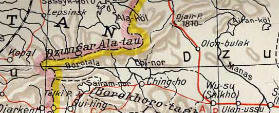
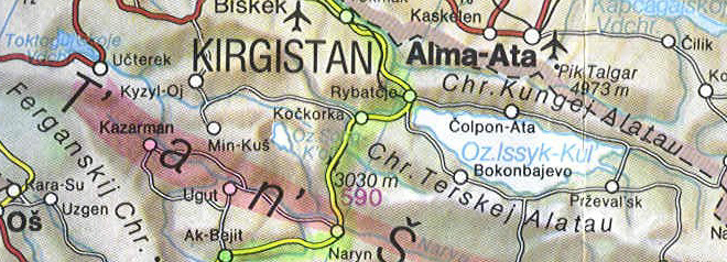
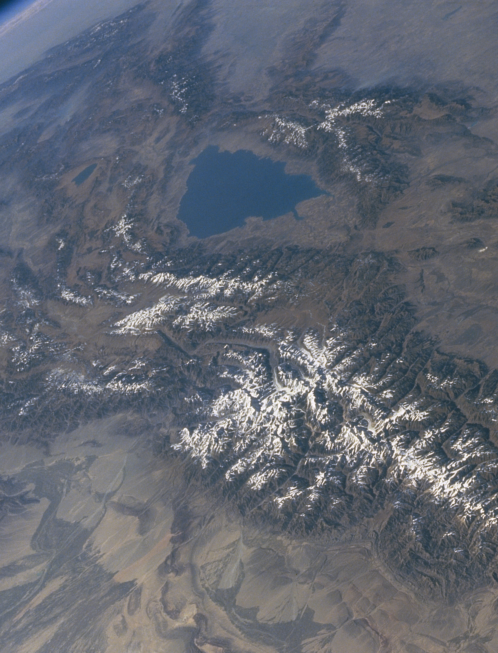
The northern extremity of the part of the Tien Shan in Kazakstan forms the Dzungarian Alatau Range (14,645 feet), which is subject to considerable glaciation. To the south the Trans-Ili Alatau Range rises abruptly above the Ili Depression to a height of 16,315 feet. The successive transition of climatic zones, determined by altitude, from arid and dry steppe at lower levels to glacial at the summit is evident on the northern slopes of this range. The Kyrgyz and Talas Alatau ranges, rising above 13,000 feet and located farther west, also belong to the outer chain of the northern Tien Shan. There is a great difference in elevation between these outer mountain ridges and the plains at their base. Streams, therefore, usually plunge down the mountainsides through deep gorges and, as they flow out onto the plains, form vast fan-shaped deposits of silt and mud. On the fertile land formed by this process are located many oases and population centres, including the cities of Almaty (Kazakstan) & Bishkek (Kyrgyzstan). The Kungey-Alatau and Terskey-Alatau ranges also belong to the northern Tien Shan. The Terskey-Alatau rises to a height of about 17,300 feet and borders the vast Ysyk-Köl Basin, the centre of which is filled by Lake Ysyk-Köl.
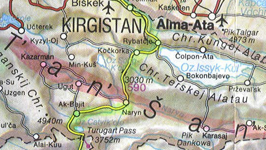
The Aksay (T'o-shih-kan in China) River basin and most of the Naryn River basin are situated within the inner Tien Shan. This region is characterized by the alternation of comparatively short mountain ranges and valleys, both extending east and west. The predominant elevations of the mountains vary from approximately 10,000 to 15,000 feet, while the elevations of the depressions that separate them vary from 6,000 to 10,500 feet. The most important ranges are Borkoldoy (16,565 feet), Dzhetym (16,178 feet), Atbashi (15,702 feet), and the Kok Shaal-Tau Range, in which Dankov Peak reaches a height of 19,626 feet.
The elevation of the mountains increases in the Sarydzhaz River basin area in the central Tien Shan, which lies to the east of the Akshiyrak Range. The separate ranges gradually converge, forming the high-altitude mountain knot already mentioned, which includes Mount Han-t'eng-ko-li and Victory Peak.
In contrast to most of the Tien Shan ranges, which run approximately east-west, the Fergana Range, separating the inner region from the western and southern Tien Shan, extends from southeast to northwest. Its maximum elevation is 16,207 feet. The southwestern slopes display a variety of climatic zones in the course of their gradual descent.
The western Tien Shan ranges lie north of the Fergana Valley. Several short but high and steep ranges running southwest-northeast here meet the southern sides of ranges running westward and northwestward. The highest peak is the Chatkal Ridge (14,773 feet), and the predominant elevations vary between 7,500 and 10,500 feet.
The southern Tien Shan ranges (including Turkistan, Zeravshan, and Alay, among others) border the Fergana Valley on the south and extend chiefly east and west. The maximum elevation is 18,441 feet, with several peaks above 15,000 feet. To the south the Tien Shan meets the Pamirs. Foothills approach the northern slopes of the ranges, and there are oases on the plains below the mountains.
References:
Encyclopedia BritannicaGeography of China - Xinhua News Agency
Road Map of Xinjiang Uyghur Autonomous Region (XUAR) (HuHai.NET)
Tian Shan Climate
(Click on Thumbnails for high resolution Images. NOTE: Some high res. images may be several MB!)The position of the Tien Shan in the centre of Eurasia governs its sharply continental climate, characterized by great extremes of temperature in summer and winter. The characteristic aridity of the region is manifest in the surrounding deserts and dry regions. The area absorbs much solar heat, and there are about 2,500 hours of sunshine each year. The climate becomes progressively cooler and more humid as the elevation of the mountains increases. Permafrost (permanently frozen subsoil) is extensive above 9,000 feet. All along the Tian Shan, the climate varies greatly because of the varied topograghy. Specifically, the regional climate can be divided into zones of continental climate, desert climate, mountain climate, the Pamir Plateau climate and the Kunlun Mountains climate.
Precipitation:
The prevalent air masses are transported over the Tien Shan by moisture-bearing westerly winds from the Atlantic Ocean. Most of the precipitation falls on the windward western and northwestern slopes at elevations between 7,500 and 9,000 feet; it varies from 28 to 31 inches (710 to 790 millimetres) at one extreme to 59 to 79 inches at the other. To the east and in the interior regions of the Tien Shan, the total precipitation decreases to between 8 and 16 inches, and it amounts to less than 4 inches in certain locations within China's Xinjiang Province. Maximum precipitation falls on the southern Tien Shan in March and April, and the summer is dry. In the western and northern Tien Shan, most of the rain falls during the warm period of the year, with a maximum in April or May. Most of the rain in the inner and eastern Tien Shan regions falls during the summer months. Many mountain valleys there are used as winter pastures because of the small amount of snow that falls in wintertime.
Temperatures:
Temperatures vary in the Tien Shan, mostly depending on altitude. Summer is hot in the foothills: the mean temperature in July may reach 81° F (27° C) in the Fergana Valley; it may reach 73° F (23° C) in the Ili Depression and up to 93° F (34° C) to the east, in the Turfan Depression, where the climate is even more continental. The temperature in July at a height of about 10,500 feet in the inner Tien Shan drops to 41° F (5° C), and frost is possible throughout the summer. The mean temperature in January in the Fergana Valley is 25° F (-4° C); in the Ili Depression it is 14° F (-10° C); and it drops to -9° F (-23° C) in the alpine regions of the inner Tien Shan, while in places (in particular, the Aksay valley) temperatures of -58° F (-50° C) have been recorded.
Climate of Xinjiang (Southern slopes of the Tian Shan, and farther south & east):
Xinjiang's climate is dry and continental, with warm summers and long, cold winters. North of the Tian Shan, in the Junggar Pendi (basin), the city of Urmuqi (which is the Provincial Capital of XUAR) has an average annual precipitation of only 178 mm (7 in), a January average temperature of -11° C (12° F), and a July average of 25'C (77° F). The city is characterized by continental steppe climate, with hot dry summers, and damp cold winters. The area south of the Tien Shan, in the Taklimakan, receives no precipitation in some years. For instance, the city of Kashgar is located in the temparate zone of this continental climate. Located in the plain climate zone with four distinct seasons, Kashgar has a long summer and a short winter. The annual mean temperature is 53° F (11.7° C), with the lowest temperature of -12° F (-24.4° C) in January and the hottest 104° F (40.1°C) in July. The frost-free period averages 215 days. The annual mean precipitation is 27 millimeters. As a result, much of the available moisture is stored in glaciers. As these melt, they feed the region's streams, rivers, and ground water, providing water for the cities and irrigated agriculture of the basins. Also, evergreen forests grow within the mountain ranges.
References:
Tian Shan Climate - Encyclopedia BritannicaUygur World
Kashgar (Kashi) Local Government Pages
Geographic Bureau - Travel in Russia & Former Soviet Republics
Please e-mail Ravi Kanda if you have any suggestions, comments or corrections.