 |
 |
 |
|
Funded
in part by  |
What are we up to
on this mission to Sumatra?
|
|
|
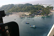
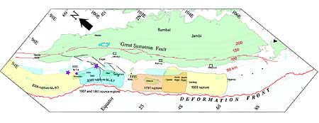
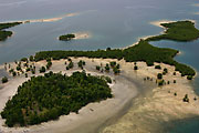
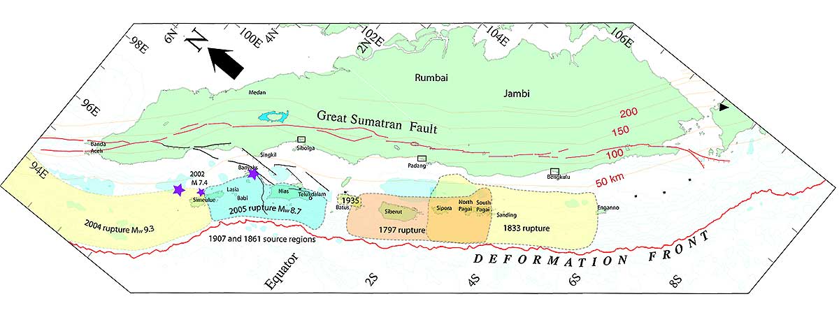
We have three goals for this month-long journey in the parts of Sumatra affected by the two recent big earthquakes: First and foremost, we want to continue and to complete measurements of the crustal deformation that occurred during those giant ruptures of the Sunda megathrust. These measurements will be important for understanding how much and where the megathrust moved during both of the earthquakes. We started to do this in mid-January and found that the northern half of Simeulue Island had risen up to 1.5 meters and had tilted toward the Sumatran mainland and toward the southeast. Now, with the March 28th earthquake, we have about 10 times as much coastline to measure uplift along! And we have places that are submerged as well. The extent of the March 28, 2005 rupture is based on what we have gleaned from eyewitness accounts of uplift and sinking as well as on initial interpretations of seismograms and our GPS data. Let’s see how good a job we’ve done figuring it out before we see it for ourselves! Second, we want to install a few seismic instruments in the region of the 1797 and 1833 giant earthquakes, because we want to be ready to collect important seismic data if that section should break in the next few months or years. We have six seismometers from Professor Clayton and four accelerometers from professors Heaton and Clayton and Ken Hudnut of the USGS, Pasadena office. Third, we have some repairs to make to some stations in our GPS network. -K.S. |
|
Thursday,
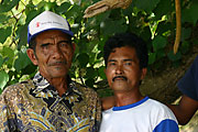
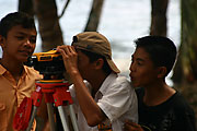
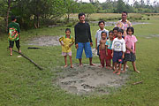
May 19, 2005: Traveling up the Mentawai islands by helicopter has allowed us to make minor repairs to the GPS stations on the Pagai islands and to install two new seismic stations on the islands (at Silabu and Nyangnyang and two on the mainland (Air Bangis and Sikuai), without delaying greatly our mission in the earthquake areas. At the island stations we have had the usual enthusiastic receptions from our local friends (Photos 1-3). #1 We’ve told them the latest results from the GPS instruments that they have been attending – they moved a centimeter or so south during the Nias-Simeulue earthquake on March 28th. After we buried the seismic sensors a meter
into the ground, we ask the local kids if they want to make
an earthquake. We get them to jump up and down and count the
number of jumps. Then we let them look at the monitor and count
the spikes, so they can see that they’ve made that many "earthquakes." #4
 In most cases the villagers tell us that they built these because they fear a big tsunami like those that have hit their neighbors to the north. But in a few cases, they have misinterpreted the title of the first version of our educational poster (“Our islands are sinking because of earthquakes”) to mean that the islands will sink during a great earthquake! Of course, the posters were created before the Aceh-Andaman earthquake, and that title was aimed at getting local people to listen to our warnings by first pointing out something that they already knew -- that their islands were slowly sinking and that this was part of the earthquake process. The drowning of jungle trees and orchards and the steady sinking of wharfs over the decades were things that many, many people on the islands new about and wondered why they were happening. Fortunately the number of islanders who have misunderstood the pre-earthquake message of the posters and brochures are a small percentage of the populace. Nonetheless, we have taken some criticism for our choice of words in the pre-earthquake materials. |
|
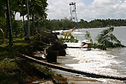
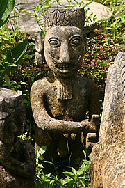
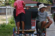
Friday, May 20, 2005: Today we flew across the Equator to southern Nias and began work along the southeastern coast. The evidence for submergence of the land at Fanedanu village, our first stop a few tens of miles north of Telukdalam, is spectacular: Row after row of coconut palms has been eroded and swept away by the surf since the earthquake. And a lighthouse now sits about 20 meters offshore, with the waves crashing around its concrete pillar foundations (Photo 5). The villagers say that before the earthquake it was about 20 meters inland. Along most of the coast in front of their village they say the sea has eroded about 50 m landward. Much of the village’s livelihood came from selling copra from the coconut palms, so they are having trouble now making enough money to keep themselves fed. The tsunami of March 28th flooded the land about 250 meters inland from the current coastline and the Dec 26th tsunami flooded only about 50 meters short of that. But the village is about 400 meters inland, so it was unflooded. In our walk through the village, we saw dozens of ancient stone carvings (Photo 6). One wonders whether or not the inland location of the village has to do with lessons learned 140 years ago, when the giant 1861 earthquake devastated the island. As far as shaking damage is concerned, only a few homes and part of the concrete-block church collapsed. It is clear that steel reinforcing kept the church from complete collapse and that a bit of steel connecting one wall to another would have kept all the walls up.This morning in Tello, we hired a pedicab driver who Bambang had used before (Photo 7). He is a young man about 25 years old, I would guess. Over breakfast at Amir’s house this morning, Bambang told us this story: About 5 years ago, the guy was making a living as a driver between his hometown in Myanmar and Thailand. On one trip to Thailand, he went with an expired passport. The Thai police arrested him and sold him to a Thai fishing boat. They enslaved him and 6 other Myanmar men as fishermen and sailors for 2 years. He told Bambang that if men got sick on the boat, they were initially given medicine to see if they would get better. If that didn’t work, they were thrown overboard, either alive or after being murdered. One day they made port at Tello, and there the 6 Myanmar men escaped and ran into the hills, emerging only after the Thai boat had left the harbor. Amir and his family took the guy in and have helped him find a way to make a living. Now he owns two passenger pedicabs and one cargo pedicab and has saved about $100, which he hopes to use to get back home to Myanmar. Just a couple months ago, Bambang delivered a letter from him to his family in Myanmar, in which he told them he was still alive and trying to earn enough money to get back home. |
|
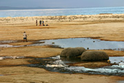
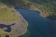
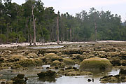
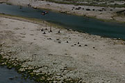
Wednesday, May 25, 2005: The past several days have been a whirlwind of activity, with two field teams going out each day to survey changes to the coastline and the boats motoring to the next port along the coast. So, there has been no time to spare to write. Today we are lying at anchor in the harbor at Gunungsitoli, taking time to resupply and rest a little. Several days ago, at Lagundri bay, the famous surfing spot on southern Nias, we measured an uplift of about 80 cm, using the old and new levels of green algae on a concrete wall that extends into the sea (Photo 8). A little farther north, we found about the same result, on a newly exposed reef littered with large coral blocks encrusted with dead mussels. |
|
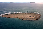
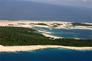
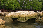
| By the time we arrived at Sirombu, a little town about half way up the west coast of Nias, we were measuring uplifts of more than two meters. The beach in front of Sirombu is now very broad. And at the harbor, most of the long wharf is out of the water and the end of the wharf is so high above the water that it can no longer be used (Photos 9 and 10).The tsunami in March was small, compared to the one in December, even though the source of the latter was much farther away than the source of the former. The March tsunami reached only to the seawall at the wharf. Thus it appears that the large uplift basically counteracted the height of the tsunami. Lavenda, a small island just to the south, is now about 10 times its former size and the former shallow reef is now out of the water (Photos 11 and 12). A new beach is forming on what used to be the outer edge of the shallow, subtidal reef. The water receded from the reef fast enough that crabs, reef fish and octopuses had too little time to escape, for their remains were common on the dried sea floor (Photo 13). Or, perhaps the concussion of the earthquake waves stunned them and left them unable to move. A bit of a miscommunication among ourselves led to half of us spending Saturday night on the porch of a home at Sirombu harbor. The guys on the boat understood that we were supposed to meet in the Hinako islands, miles offshore from Sirombu. The rest of us thought the agreement was to meet up in Sirombu. We waited for the boats to arrive, with most of our personal gear, dinner and our bunks, but for naught. An hour or so after dusk, a family at the harbor offered us a small meal and company on the porch of their home, while we waited. The woman who cooked for us had lost her home in the December 28th tsunami. When it became clear that our boats were not going to arrive, the family offered the use of their well for bathing. The water level has dropped a meter since the earthquake, to a level 4 meters below the floor of the room. The rope on the bucket is now very long! We talked until 9 or so and then they spread woven mats on the porch for us to sleep on. Hordes of mosquitos made sure that no one slept very well there. In the Hinako islands on Sunday, we measured uplift in several places. Steve, who runs the surfing resort on Asu, the northernmost of this cluster of small islands, welcomed us when we landed on the beach nearly in front of him. He and his staff were eager to learn what we could tell them about the reasons for the earthquake and tsunami and, more importantly, what might the future bring. He has been living and surfing on Asu for about a quarter century, so he knows the reefs well. He reported that the rocky reefs there were never above water before the March 28th earthquake. Now they are permanently above. The surfing waves have changed, some for the worse, but some for the better. Sunday night, we anchored off the east coast of Wunga island, near the northwestern tip of Nias. Twelve years ago, when I had just begun to explore the earthquake story of the islands, the fishing boat we had hired took us into the big beautiful blue lagoon that fills most of the center of this C-shaped island. |  #8 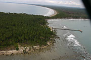 #9 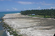 #10 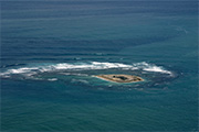 #11 |
| It was there that I first donned mask
and fins to explore the reef with my friend and colleague, Fred Taylor.
The back of the “C” is on the west and the opening is
on the east. I remember that an elderly man there told us that his
grandfather had taught him that in 1907 a large tsunami had washed
across the island from the west, cutting it in two. Twelve years
ago, one could in fact see there were shallow gaps in the back of
the “C,” across which waves would wash at high tide.
The island is now more than half barren reef, inset into which are
the half dozen or so small green islets that once formed the C-shaped
cluster. The bay has shrunk from uplift to a fraction of its former
size (Photos 14 and 15). We anchored offshore of
the opening, because it is now too shallow to enter. Uplift here
is about two meters. Yesterday, we started to work east along the
northern coast of Nias island. Measurements from the emerged corals
near the town of Lahewa are yielding uplifts nearly as great as that
recorded by the GPS station that Galetzka and crew installed in February – nearly
3 meters. What the corals can’t give us are the horizontal
motions during the earthquake. People here are astonished to learn
that the GPS instrument recorded more than 4 meters of motion toward
the southwest during the earthquake. As we suspected, though, the uplift diminishes rapidly toward the east to zero near the northeastern tip of the island. Here at Gunungsitoli, on the east coast of the island, the change in elevation is so slight that it is not easy at first glance to tell whether the land has sunk or risen. |
 #12 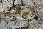 #13 #13 |
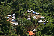
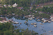
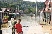
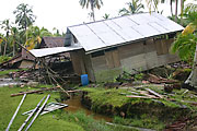
Thursday, 26 May 2005: Today we began to explore the Banyak islands, closer to the Sumatran mainland and between Nias and Simeulue islands. We chose to meet in what we thought was Balai, the capital of the region, in order to check in with the local authorities. We had never been to any of these islands before and were aware of their political sensitivity. But the town we landed in, on the northern coast of Tuangku, the largest of the islands, is Haloban, not Balai. Half way through our inspection of Haloban, we were ordered to immediately fly east to Balai to report in. Both there and at Haloban, we had a warm reception from leaders and residents. Throughout the region, evidence for submergence is clear. Mangrove forests fringing the coasts show massive mortality (Photo 18). Haloban and Balai have both sunk so much that waterfront roads are canals during high tides and buildings stand partially submerged (Photos 19 and 20). At Haloban, a waterfront coconut grove is now flooded and, in fact, a new beach is forming within the grove (Photo 21). At both Haloban and Balai, refugees from flooded waterfront homes are building shelters in public areas around grassy playing fields (Photo 22). The great community spirit in these places is clear; everyone is helping the less fortunate. Despite the immense challenges of reconstructing their livelihoods with little support from the outside world, most are in good spirits. The young men commonly come out to watch us survey the amount of submergence (Photo 23).
|
|
Friday, 27 May 2005: Sinabang harbor is a sight to behold; what remains of the concrete dock sags enormously and the pilings are covered with dead encrusting marine organisms that no longer are submerged enough to have survived (Photo 25). Boats are laden with scrap metal from the destroyed buildings here and are delivering their cargo to the mainland. Relief ships are still arriving. At the airport, the modest terminal building collapsed and has already been replaced by a smaller, lighter structure. In January, I was amazed to see so little damage from the first big earthquake to structures along the road from the town to the airport. Now I am amazed at how much damage has been wrought by the second, smaller big earthquake. Structures are damaged or down everywhere. The hotel in which we stayed in January burned to the ground after the earthquake, along with most of the buildings in the neighborhood. |
|
Saturday, 28 May 2005:
|
Today Aron, Nug and I measured uplift on the small islands west
of Simeulue (Photos 26 and 27). |
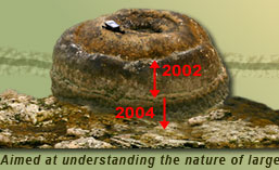
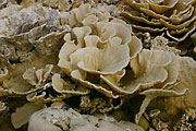
Sunday, 29 May 2005: So, unlike the southeastern coast of Nias, which submerged on March 28th, the eastern coast of Simeulue has risen. Today both survey teams measured emergence along this stretch of the coast. In one large, murky, mangrove-lined bay, Nug, Aron and I found a family of coral microatolls that clearly shows emergence about two years before emergence during the March 28th earthquake (Photo 31). Most likely this is evidence of the November 2002 M 7.4, which we now recognize was a precursor to both giant earthquakes and appears to have occurred precisely between their rupture planes. |
|
Monday, 30 May 2005: We’re overnighting in Telukdalam, tonight, the central of three large bays along the eastern coast of Simeulue. Quiet here, without the harbor sounds of Sinabang. Just the lights of a home a couple hundred meters away at a small dock. More evidence for uplift as we proceeded today farther north up the eastern coast of Simeulue island. The changes in the landscape are spectacular, but they are everywhere and everyday, so we are becoming used to the spectacular! More old drowned coconut groves now out of the water (Photo 32), more islands now connected across barren new ground (Photo 33), more beautiful dead corals (Photo 35), more reefs now starting to support the growth of grasses and small trees (Photo 34). #32 #34 |
|
Tuesday, 31 May 2005: Today, I particularly enjoyed a time that the NG crew filmed with four local fishermen who paddled over to the helicopter as it sat waiting for us on a little beach. By the time I had swum over from our survey site across the mouth of a little bay, our pilot Machfuld, was translating between director, Simon, and the fishermen. Simon was asking them really good questions about their experiences during the earthquakes and tsunamis. They were saying that they were frightened that their world had become so uncertain in the past few months. Things they had thought so reliable, the sea and the landscape, had changed, and they were worried that there might be more changes. Simon asked them if they thought it would help if they knew more about why the earthquakes and tsunamis had happened, and they responded enthusiastically in the affirmative. It was a natural opening to drag out the few copies of the new Nias-Simeulue poster that I’d brought along. So, they filmed us talking about the reasons for all these changes. The fishermen seemed relieved to hear that it takes many decades or longer for the earth to prepare for an earthquake and that without a big earthquake, another tsunami is exceedingly unlikely. Tonight we are anchored in the small harbor of Lewak, a small village on the northeastern tip of Simeulue island and the closest habitation to the epicenter of the December 26th earthquake. One of the four new GPS sites that we established after the first earthquake is on the hill just above the town (Photo 36). |
|
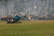
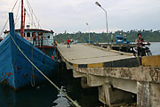
| In the photo you can see the cargo boat that is
carrying all our helicopter fuel. Next to it the small fishing boat
that the NG crew rented for an arm and a leg to help them get around.
Their “fixer,” the Indonesian guy who made their arrangements,
told them it would be fully outfitted for them and that it slept
ten. We are wondering if he was referring to people or to chickens! We
have loaned them blankets and mats and invited them to dine with
us and use our toilet and shower facilities, as the little fishing
boat has none of these things. When we landed at Lewak late this afternoon, we got the usual warm greeting from dozens of men, women and children. In addition, though, one old man was so grateful for our presence that he kissed both Aron and myself on both cheeks! |
 #36 #36 |
| Jean-Philippe and our French crowd
in the Tectonics Observatory would feel right at home here. These
villagers would have been the first in the world to feel the beginnings
of the giant earthquake that would in the following minutes and hours
change so many lives around the Bay of Bengal forever. Imam recorded
a video of their interview in early February of a man who saw, from
the hill, the tsunami bore roil into the bay here. Tomorrow morning, we plan to cut one of the dead coral microatolls on the reef platform on the other side of town. John and Imam found some particularly beautiful ones when they visited here to install the GPS station here last February. The NG crew was particularly interested in filming this aspect of our research, so Dudi and crew have dusted off the chain saw, engine and waterpump and carted it to the boat from Bandung. Cutting a slab now will give us a chance to see whether or not there were any anomalies in sea level changes in the decades prior to the earthquake. |
|
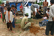
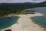
Wednesday, 1 June 2005: Tonight we’re anchored on the protected side of the small island north of Ujung Salang, on the west coast of Simeulue. Rich, Danny and Nug used the helicopter to hop from reef to reef along the northern coast of the island, measuring uplift, while the rest of us remained behind to cut the coral at Lewak. We’ve rendezvoused here, minus the NG crew, who started motoring back to Sinabang along the east coast early this afternoon. They need to catch their plane out tomorrow morning. We cut a nice slab of coral this morning at Lewak. Several men helped us lug the equipment the few hundred meters through town to the reef and to lug it and the sample back to the boat (Photos 38 and 39). Today we realized that all the uplift along the northern coast, between Lewak and Ujung Salang, occurred during the December earthquake. The guys have found no differences between Danny’s and my measurements in January and today’s measurements (Photo 41). We have now shown that the December and March uplifts overlap only slightly and that there is a clear saddle in the uplift values between the uplift regions of the two giant earthquakes. Here at Ujung Salang the emerged reef has matured appreciably in the four months since Danny and I visited. Grass has begun to grow on the reef platform and even on the tops of some of the coral microatolls. I wouldn’t be surprised if within ten years the whole reef is covered in grasses, shrubs and small trees. It will be interesting to see if the farmers replant coconut groves on the new ground. And there is a new beach forming on the edge of the newly emerged coastline. Photo 42 shows the new beach strand along the new coastline. The old village, in the trees on the left was almost completely destroyed by the December 26th tsunami; a new town is being built against the hill on the right. The lines of trees above the new village are a clove orchard.The fishing boat that we saw in the trees last January has been carried out onto the reef and is nearly repaired and ready to return to the sea. How they are going to get it over the 1.5-m high new beach is a mystery to me. Will they shovel a path through it or just brute-force the ship over it? The captain of the boat came over to ask me for a “souvenir,” that is a handout. I asked him where he was during the tsunami that carried the boat into the trees. I was amazed to hear him say that he was on the boat and rode out the tsunami on it. He described how the sea first sucked him out as it receded. The sea then came back at him as a 5-meter-high foaming bore, which he headed directly into and managed to ride over it. He and the ship were sucked back out and sent back in again twice. The third wave carried the boat into the woods and left it there. Do I believe this story? Not sure. |
 #38  #39  #41 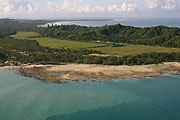 #42 |
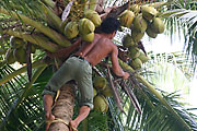
Friday, 3 June 2005: Well, last night Aron, Nug and I were abandoned by the helicopter and thought we would end up spending the night in a small town half-way up the west coast of Simeulue. Machfuld had been shuttling both survey crews southward along the coast in a leap-frog manner all day. By mid-afternoon he needed more fuel, so he headed south to our pre-arranged anchorage for the night, Busong bay. Unfortunately, the cargo boat had gotten the wrong information about the rendezvous point and was nowhere to be seen. It didn’t arrive ‘til about 5:30, so the fuel couldn’t be gotten into the helicopter until just before dark. So the helicopter had to stay put for the night. We had no way of knowing this of course, so we just passed the time shooting the breeze with a crowd of local guys who had come out to find out what we were doing. When we all had gotten a little hungry, an hour or so before sunset, one of the younger guys fashioned climbing gear out of two pieces of tree bark and climbed one of the coconut palms to retrieve a half dozen coconuts (Photo 43). |
|
| By six thirty we knew we’d not
be getting back to the ships by helicopter and began discussing our
options with our new friends. They offered to find a friend who had
a car and drive us back the 3 or so hours to our boat; or they would
ask the village mayor to house us for the night. As we sat in a small two-room home, lit by a lone kerosene lamp, we talked about the earthquakes and tsunami and how it had unsettled their lives. Our expressed opinions that a repetition of the giant earthquakes there was not likely for decades or longer calmed them and they were thankful for our explanations and opinions. About seven thirty or eight a young guy came by with a pickup and we began Mr. Toad’s Wild Ride through the countryside. I rode up front with Ikbar, our 20-something driver; Nug and Aron rode in the bed of the truck. Ikbar had been living in Meulaboh at the time of the earthquake and tsunami of December 26th. Of the 100,000 or so inhabitants, he and his parents were among the 25,000 or so to survive. He said that he and his parents had been taught about the 1907 Simeulue tsunami and knew to run for the hills when the sea withdrew after the earthquake. Today we were joined by another film crew. These two guys, Edwin and Roeland, are from a production company that is doing a piece for Discovery Channel. In the morning they filmed us cutting two corals from the small island in the middle of the bay and did a little bit of flying around for their benefit. Rich, Danny and Nug used the helicopter in the morning to finish up our measurements here on Simeulue. Tonight both boats leave on the long trip back down south to Nias, expecting to reach Gunungsitoli tomorrow mid-day or so. I’ll stay with Machfuld, Edwin and Roeland at a surfer’s house on shore tonight. We’ll fly down to Nias tomorrow morning and spend the day filming. |
|
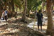
Saturday, 4 June 2005: Last night in the field, anchored here in Gunungsitoli harbor again. Aron and Rich, Imam and Nug will stay on to finish up measurements, especially in the Banyaks, where we have only two measurements to constrain the pattern and magnitude of submergence. The highlight for me today was our stop at a small village at the mouth of a small river on the north coast of Nias. Flying over a couple weeks ago, I had seen striking evidence of liquefaction of the delta sediments, so I thought this might be a rather spectacular place to film the effects of a large earthquake. Hundreds of light gray sandblows dot the fields just outside the town (Photo 44). These are a common occurrence on the loose, saturated sandy sediments at the mouths of rivers. Residents told us the fountains of water and sand began about half-way through the shaking of the March 28th earthquake and that water continued to flow up to four days afterwards. In the town, which sits on the west side of the river, large fissures opened up and wrecked many of the houses and the mosque (Photo 45 and 46). Our last stop of the day was at Onolimbu, a town on the easternmost tip of Nias, and also at the mouth of a river. There was no obvious evidence of liquefaction there, but compaction of the river sediments had caused much of the town to settle down into the intertidal zone. Much of the town is now flooded during higher tides and some homes and former beachfront has actually slumped meters down beneath the sea (Photo 47). |
|
#46 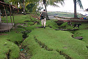 #47 #47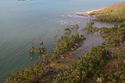 |
|
