The 2005, Mw 7.6 Kashmir earthquake:
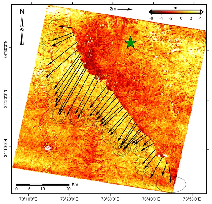
Sub-pixel correlation of ASTER images

The color image represents the northward ground displacements (positive to the north), determined from the correlation of ASTER images, with a 15-m ground resolution, taken on November 14, 2000 (AST_L1A.003:2003527667) and on October 27, 2005 (AST_L1A.003:2031572195). The incidence angle is 8.6° for both images. This correlation image was obtained with a sliding
32×32 pixels correlation window and 8-pixel step, leading to a ground resolution of 120 m.
No measurement is assigned to white points, where the correlation is lost or where outliers (where the measured ground displacement was found to exceed 10 m) have been filtered out. Correlation is lost mainly due to landslides or variation of the snow cover.
Arrows represent the horizontal surface fault slip. They are determined from linear least sqaure adjustment, on each side of the fault and on each NS and EW images, of stacked profiles running perpendicularly to the rupture. Profiles are stacked over a width of 6 km and a length of 18 km. Ellipses show the 95% confidence intervals.
© 2004 Tectonics Observatory :: California Institute of Technology :: all rights reserved
NSF logo
 
Funded in part by National Science Foundation grants EAR 0409652 & 0636097
izmit turkey earthquake aerial images