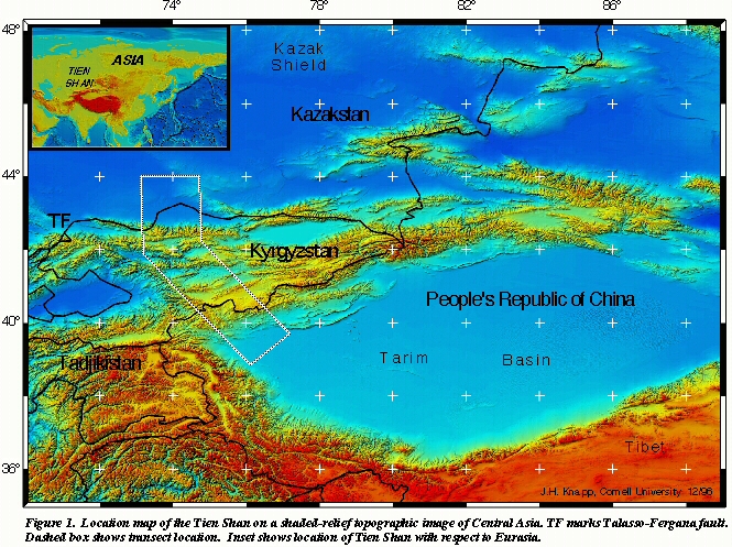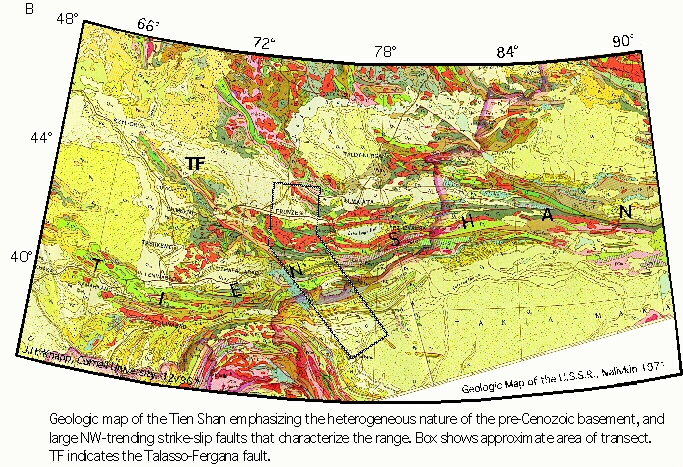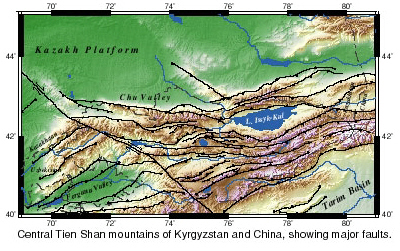
Figure Courtesy: Charles Rubin, CWU

Figure Courtesy: Charles Rubin, CWU

Figure Courtesy: Charles Rubin, CWU

Figure Courtesy: Charreau et al., 2005
The mountains of the Tien Shan are composed mainly of crystalline and sedimentary rocks of the Paleozoic Era (from 540 to 250 Ma). The inter-montane basins are filled with younger fluvial/lacustrine sediments. Intrusive igneous outcrops can be seen over much of the area in the north and east of the Tien Shan, which underwent folding during an early-Paleozoic orogeny. It has been uplifted and dry since then, so its original sedimentary cover has been almost completely eroded. The southern and western parts of the Tien Shan, however, consist principally of meta-sedimentary rock and, to a lesser extant, of intrusive and extrusive volcanics. These regions experienced folding during the late Paleozoic. A new stage of development began in the middle of the Tertiary Period (~ 25 Ma) and has continued to the present time. The primary evidence for this comes from the presence of foreland sedimentary strata (primarily conglomerates) that have been dated to be from this period (Charreau et al, 2005 - Reference [E1] below). Shallow lakes that formed in many valleys/basins & the arid climate during this time created ideal conditions for vast evaporite deposits. Subsequently, glaciers deposited boulder moraines in the mountains, while gravel and loess strata accumulated in the valleys. The boundaries between inter-montane basins and adjoining ranges are defined by steeply dipping fault zones (Vinnik et al., 2002, Wang et al., 2004 - Reference [B5] below).
Tectonics - Summary:
It is thought that nearly half of the present-day Indo-Asian convergence is absorbed by deformation roughly 1000-2000 km north of the Himalaya, within the interior ranges of Central Asia (Bullen et al., 2003, Reference [B4] below, and bottom right figure panel above) - namely, the Tien Shan and Altai Ranges. Geodetic studies indicate that the present shortening rate in the Tien Shan is approximately 20-23 km/m.yr. (mm/yr), which is similar to the shortening rate across the main Himalayan Thrust (Avouac, 2003, Reference [A7] below). Rapid shortening in the Tien Shan has created the highest summits outside of the Himalaya. As such, the Tien Shans are make a unique case-study of intracontinental mountain building. The timing of the initial growth of the Tien Shan remains controversial. Magneto-stratigraphic sections and fission track ages in the eastern and southern Tien Shan indicate that erosional exhumation of these ranges began at 20-25 Ma and may have been linked to a switch from extrusion-dominated to crustal thickening- dominated tectonics. Alternatively, initial Tien Shan growth has been estimated at approximately 10 Ma on the basis of extrapolation of the geodetic shortening rate, given that the total Cenozoic shortening across the Tien Shan has been estimated at 200±50 km.
Recent work by Rowley (2006, Reference [A8] below), based on oxygen-isotope-based estimates of the palaeo-altimetry of late Eocene and younger deposits of the Lunpola basin in the centre of the Tibetan Plateau suggest that it was created rapidly, and has remained uplifted for the past 35 million years. If the Traim block can be considered rigid, then it is possible that it could have acted as a stress guide, transferring deformation to its northern margin, to cause the Central Asian ranges to uplift. Either of the above dates for the initiation of deformation at the northern edge of the Tarim Basin is consistent with this progression of deformation from the Himalayan front to the present location of the Tien Shans. But the issue is whether this transfer of stress took approximately 10 Ma (as suggested by magneto-stratigraphic sections & fission track ages) or 25 Ma (as suggested by the extrapolation of geodetic shortening rate).
Topical References:
A. India-Asia Collision Dynamics:[A1]Flesch, L. M., Haines, A. J., and Holt, W. E., 2001, Dynamics of the India-Eurasia collision zone: J. Geophys. Res., v. 106, p. 16435-16460
[A2]Avouac, J., and Tapponnier, P., 1993, Kinematic model of active deformation in central Asia: Geophys.Res.Lett., v. 20, p. 895-898.
[A3]Neil, E. A., and Houseman, G. A., 1997, Geodynamics of the Tarim Basin and the Tien Shan in central Asia: Tectonics, v. 16, p. 571-584.
[A4]Wang, et al. Q. Z., 2001, Present-day crustal deformation in China constrained by global positioning system measurements: Science, v. 294, p. 574-577.
[A5]Holt, W. E., et al., 2000, Velocity field in Asia inferred from Quaternary fault slip rates and Global Positioning System observations: Journal of Geophysical Research-Solid Earth, v. 105, p. 19185-19209.
[A6]Thatcher, W., 2003, GPS constraints on the kinematics of continental deformation: International Geology Review, v. 45, p. 191-212.
[A7]Avouac, J. P., 2003, Mountain building, erosion and the seismic cycle in the Nepal Himalaya., Advances in Geophysics., v. 46, Amsterdam, Elsevier.
[A8]Rowley, D.B., and B.S. Currie,2006, Palaeo-altimetry of the late Eocene to Miocene Lunpola basin, central Tibet,Nature, v. 439, pp.677-681. doi:10.1038/nature04506
B. Fold and Thrust Belt of Northern Tien Shan:
[B1]Molnar, P., et al., 1994, Quaternary Climate-Change and the Formation of River Terraces across Growing Anticlines on the North Flank of the Tien-Shan, China: Journal of Geology, v. 102, p. 583-602.
[B2]Avouac, J.P., P. Tapponnier, M. Bai, H. You and G. Wang, Active thrusting and folding along the northeastern Tien Shan and late Cenozoic rotation of Tarim with respect to Dzungaria and Kazakhstan, J. Geophys. Res., 98, 6755-6804, 1993.
[B3]Poisson, B., and Avouac, J. P., 2004, Holocene hydrological changes inferred from alluvial stream entrenchment in North Tian Shan (Northwestern China): Journal of Geology, v. 112, p. 231-249.
[B4]Bullen, M. E., Burbank, D. W., and Garver, J. I., 2003, Building the Northern Tien Shan: Integrated thermal, structural, and topographic constraints: Journal Of Geology, v. 111, p. 149-165.
[B5]Wang, C-Y; Yang, Z-E; Luo, H; Mooney, W D, 2004, Crustal structure of the northern margin of the eastern Tien Shan, China, and its tectonic implications for the 1906 M7.7 Manas earthquake, EPSL, v. 223, pp. 187-202.
C. Deformation in the Kyrgyz Tien Shan:
[C1]Thompson, S. C., et al., 2002, Late Quaternary slip rates across the central Tien Shan, Kyrgyzstan, central Asia: Journal of Geophysical Research-Solid Earth, v. 107, p. art. no.-2203.
[C2]Bullen, M. E., Burbank, D. W., and Garver, J. I., 2003, Building the Northern Tien Shan: Integrated thermal, structural, and topographic constraints: Journal Of Geology, v. 111, p. 149-165.
D. Fold and Thrust Belt of Southern Tien Shan:
[D1]Hubert-Ferrari, A., J. Suppe, R. Gonzalez-Mieres, X. Wang, 2006, Active Folding of the Landscape in the Southern Tien Shan [Manuscript not yet submitted - password required]
[D2] John Suppe group's recent publications:
Several papers that have either been submitted or in preparation are listed there. They study various aspects of seismo-tectonics in the southern Tien Shan. Please contact John Suppe directly for more information on these papers.
E. Foreland Sedimentation
[E1] Charreau, J., Y. Chen, S. Gilder, S. Dominguez, J.P. Avouac, S. Sen, D. Sun, Y. Li, and W.M. Wang, 2005, Magnetostratigraphy and rock magnetism of the Neogene Kuitun He section (northwest China): implications for Late Cenozoic uplift of the Tianshan mountains, Earth and Planetary Science Letters, v. 230, pp. 177-192.
[E2]Bullen, M. E., Burbank, D. W., and Garver, J. I., 2003, Building the Northern Tien Shan: Integrated thermal, structural, and topographic constraints: Journal Of Geology, v. 111, p. 149-165.
F. General References:
Geology of the Tien Shan - Encyclopedia Britannica
Tien Shan Field Trip Guide:
Fieldguide for South and North Tien Shan Foreland Basins, XUAR, China (NOTE: ~40 MB!)High Resolution Version (NOTE: ~260 MB!!!, Princeton University Geoweb)
Courses & Field Work Links:
Ge 277: Mountain Building in Central Asia (Course Webpage)Ge 277 FTP Site
Tien Shan Geophysics Field Trip - Steve Roecker (Reconnaissance Notes & Seismic Network Installation)
Geologic Images & Maps:
Ge 277 PresentationsSouthern Tien Shan's Image Gallery (John Suppe)
Jan Esper's Homepage (WSL)
Geodynamics of Tien Shan (Charles Rubin, Central Washington University)
Regional Geological Agencies & Departments:
Institute of Geology and Geophysics, Chinese Academy of SciencesChina Geological Survey
Xinjiang Geological & Minerals Museum (ChinaCulture.ORG)
Geological Survey of Kyrgyzstan (Russian/Engilsh)
Kyrgyz National Academy of Sciences: Institute of Geology
Central Geological Laboratory, Mongolia
Mongolian Geologists & Geophysicists Association Contact Info
NOTE: Kazakhstan and Tajikistan do not have specific geological agencies/institutes at this time. Instead, all mineral exploration/mining is carried out through government ministries. While Kazakhstan has vast mineral resources that are overseen by its Ministry of Energy & Mineral Resources (MEMR), Tajikistan has limited but varied mineral resources that are overseen by its Ministry of Energy.
Please e-mail Ravi Kanda if you have any suggestions, comments or corrections.