|
|
Until 2004, there were three main arguments against a large earthquake in the Sumatra region. The December earthquake proved them wrong.
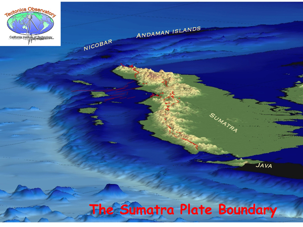
The oceanic crust of the subducting plate at the location of the 2004 earthquake is old and therefor dense. Young crust, in contrast, is light and buoyant, and therefore would stick more tightly to the upper plate. It was thought that only the subduction of young, bouyant crust could produce giant earthquakes. Plate motion at the location of the 2004 earthquake is slow. For large earthquakes to occur, it was thought that the convergence rate had to be fast. Islands are scattered throughout the Sumatra region. Prior to 2004, it was thought that a large earthquake could only occur in a subduction zone free of islands (or more precisely, with no back-arc spreading).
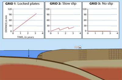
It was clear after the unexpected giant earthquake of 2004 that new criteria were needed for assessing earthquake risk. Scientists suspected that earthquakes rupture areas of the plate interface that had remained locked during the interseismic period. But because these patches of locked fault zones are located deep within the Earth's crust, how could this idea be tested? Moreover, how could the location and size of earthquakes and locked fault zones that occurred in the past be determined? Not an easy task.
Even though patches of locked fault zones are located deep in the crust, they deform the land at the surface above them; some places subside and others uplift. Thus by combining surface deformation measurements with computer models of how the underlying dynamics at plate boundaries deforms the land above, TO scientists have mapped out the locations and sizes of locked fault zones.
One way to measure surface deformation and motion is with Global Positioning System (GPS) stations. These modern instruments can detect surface motion to unprecedented precision (a fraction of a mm per year). However, GPS instruments date back only to 1991.
Animation of How GPS is used to Track Plate Motion Credit: Taken from UNAVCO web site
To measure surface deformation over an even longer period of time, TO scientists take advantage of an inhabitant of Sumatra's ocean environment: the local coral. For more information, see Using Coral to Track the History of Earthquakes.
From GPS measurements and studies of coral growth patterns, TO scientists were able to measure surface deformation over the past 40 years. When these data were incorporated into the TO's computer models, the scientists were able to determine the locations and sizes of fault patches that had remained locked over this period (see Figure 2). Also the scientists have compared these locked patches with the rupture area of the recent and historical earthquakes, also shown in Figure 2.
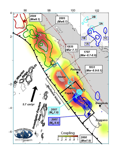
Figure 2. Strength of locking and location of earthquakes. Credit: TO, modified from Konca et al., Nature 2008
A correlation between the two became clear. TO scientists discovered that the locations of locked fault zones during quiet times in between earthquakes match the locations of the earthquakes that inevitably happen.
Detailed and useful information for assessing earthquake risk comes out of these studies:
In regions where no large earthquakes have occurred, the fault zone that remains locked during the inter-seismic period is relatively narrow, typically 10 km (6 miles) in width In regions where the great earthquakes have occurred in the past, the fault zone that remains locked during the inter-seismic period is 10 times larger, up to 175 km (110 miles) in width
This means that by imaging locked fault zones when there are no earthquakes, geologists can assess how large a future earthquake might be. Where stress is building up over large, locked areas, massive earthquakes will occur in the future.
Moreover, several regions around the globe that were overlooked in the past now need to be re-evaluated for their earthquake hazard.
The region of the subduction zone near Sumatra, as the world learned after the 2004 earthquake, is one example where work still needs to be done. The area west of Java has very old crust subducting at a moderate rate (~6 cm/year), and so had been considered at low risk for earthquakes. This new TO work indicates that that region's locked fault zone patches should be evaluated for location and size. Other areas that need to be reassessed for earthquake hazard are, for example, the Ryukyu Islands between Taiwan and Japan, and the Caribbean Islands.
Learn more:
- Introduction
- Why Earthquakes and Tsunamis Occur in the Sumatra Region
- What Happened During the 2004 Sumatra Earthquake
- Using Coral to Track the History of Earthquakes
- Rethinking the Causes of Giant Earthquakes
|