|
Importing GMT gridfiles into ArcGIS via ENVI
Q: Can GMT gridfiles be imported into ArcGIS: ArcInfo desktop? A: No, not directly anyway. The .grd file can be imported into any number of image processing software packages which will allow you to transfer your data later to ArcGIS.
Procedure:
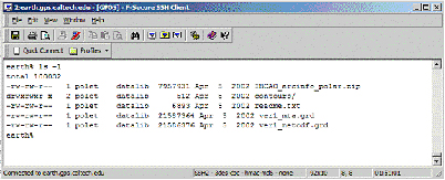
Check for file size of the .grd file. Since most GMT users will store their data on Earth, we will use Unix commands available through SecureShell.
Start SecureShell Client On Earth, navigate to where the data is located and retrieve the grd filesize (# of bytes). Record the filesize for later use. earth% ls -l
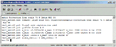
Retrieve details of the *.grd file using grdinfo. earth% grdinfo ver1_netcdf.grd
Assuming the grd file is stored as a floating point datatype, multiply 2323 * 2323 * 4 Subtract the recorded value from the results retrieved from grdinfo (2048).
Using ENVI ENVI will allow you to access the grd file directly.
On the command bar File>Open Image File>Navigate to *.grd>Open image file
|